
featuring Connor Mockett
Hello, everyone! Welcome back to The Weather with Connor. This week’s column will be a little bit different, I’m going to talk about my Top 3 favourite storm chases that I’ve ever been on. There were lots to choose from over the years, but I think I’ve made my mind up!
Number 3: September 5th, 2021.
 This day was a complete surprise. I was expecting storms this day, but nothing quite as photogenic as what I ended up seeing. I actually didn’t even prepare for a chase day, because after looking at models, I wasn’t all convinced anything cool was going to happen. Boy, was I wrong.
I was sitting at home, periodically checking radar for most of the afternoon and early evening. Around 5:00pm, I started to get intrigued by a storm over by Casselman, mostly because I could see the crisp updraft in the distance from Winchester, and it was showing some minor rotation on radar. Because of those things, I quickly prepared my car and cameras for an emergency chase.
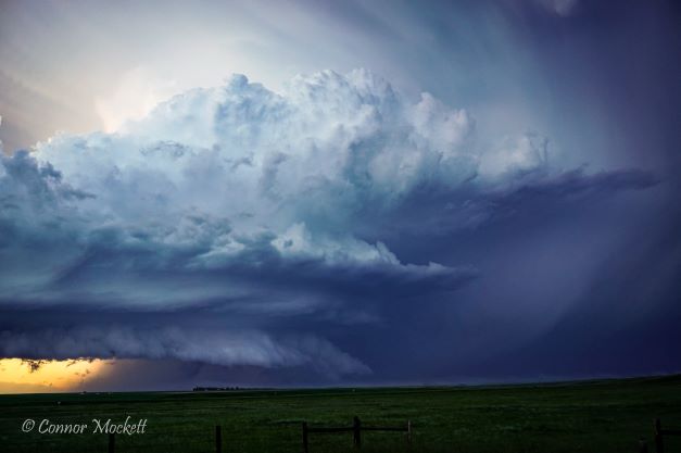
I ended up catching up to the storm around Moose Creek. It was a relatively slow moving storm, which is not common around here. Right off the bat, I saw a minor funnel cloud pretty much directly over Casselman, but the storm visually looked like it was dying. I kept with it, though. From Moose Creek, I followed it all the way to just east of Alexandria, and during that drive, it progressively got prettier and prettier, and then I was in shock at what I was seeing.
I stopped the car near Glen Robertson, Ontario, right at the Quebec border. I hopped out of the car, and saw a big beautiful shelf cloud, with the sun from behind the storm shooting directly through it, making the underneath of the storm a bright orange. A gorgeous sight.
Number 2: June 27th, 2022.
 This was one of my Alberta chases from my Chasecation last summer. This was one of those days where the Alberta Foothills are playing games with you for a little bit, until storms really pop off. Supercells were expected to fire up off the foothills in the late afternoon and early evening around Calgary.
Right around dinner time, the first storm of the day fired up, but it was a weird one. It was moving straight north, following the edge of the foothills, and was never able to come off the mountains to tap into a better environment. It was also moving about 100km/h, which is very difficult to chase, especially in rush hour in Cochrane, Alberta. I tried my best to follow that storm, but I got stuck in traffic, and the storm later died. I was frustrated, that’s for sure, so I went and parked at a gas station just north of Cochrane, thinking the day was a bust…until it wasn’t.
While on my phone looking for potential hotels to stay at for the night, I suddenly look up and see a huge updraft off to my south. A new supercell thunderstorm had just come off the Foothills, and was immediately dangerous. It went to a tornado warning pretty quickly, and did show a couple of funnels as other chasers reported. However, I was far away, and had to catch up to it from Cochrane to Strathmore, Alberta. I ended up catching it, and boy was I happy about that. I got out in front of the storm, took the camera out, and started taking photos. This photo was in my 2023 Calendar, and is one of my all-time favourites. This was taken near Hussar, Alberta at 10:15pm.
Number 1: July 15th, 2021.
 This was another emergency chase type of day. On a Thursday morning, I got to looking at the weather models, because severe storms were expected late in the day for Eastern Ontario. Fun fact, this day was the same day and the same system, which caused the Barrie, Ontario EF-2 tornado that afternoon.
I was on the couch going over things in my head. I noticed models had a storm or two Thursday afternoon in the Ottawa Valley, so I started looking at the parameters to see if it was worth giving it a shot. I know the Ottawa Valley terrain and road network very well, so it was (and always is) attractive to chase up there. I really contemplated going or not, so I gave myself a 10 minute period to tell myself if I was going or not. Naturally, my storm chasing brain told me to go, so I did. A non-planned chase into the Valley.
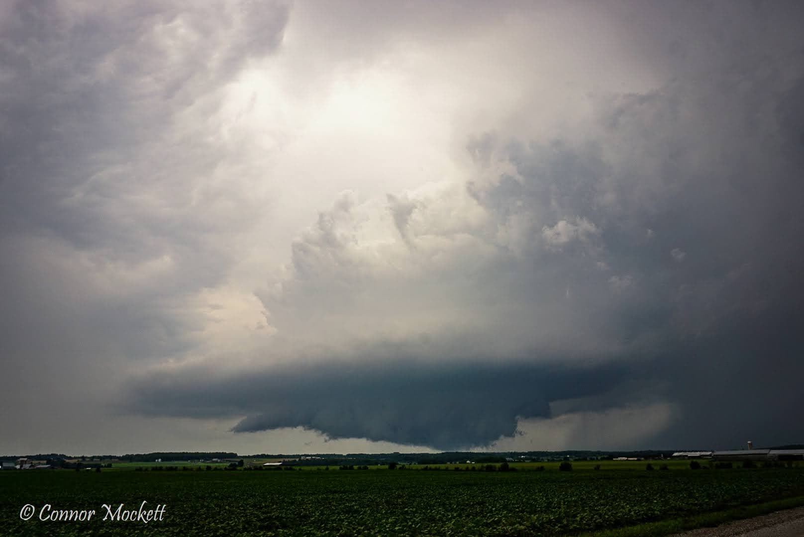
Another fun fact, the CASFT Franktown radar that Environment Canada has was not up and running yet, as it was still being installed that summer. So I had no radar to look at before or during this chase, it was completely visual chasing. I got into my target area, just northwest of Renfrew, Ontario. As I’m sitting on a dirt back road in the open fields, I notice the cloud cover. I actually almost left because of the clouds. Once again, glad I didn’t!
As I’m sitting there, I see my target storm coming into view. At the time, it was just entering the town of Golden Lake/Eganville, but I could still see it. Immediately, I noticed a lowering, right where it should be for a supercell (the southern part of the storm). It started to get closer and closer, close enough where I could visually see strong rotation happening in the clouds and wall cloud. I drove further north, about 1.5km, to get to another dirt road. This is where structure was most amazing. You really don’t see this type of supercell structure around here very often at all. I was really seeing rotation, and to this day I still cannot believe this storm didn’t put down a tornado.
This was, and still is, the most beautiful supercell I’ve ever personally laid my eyes on in my Ontario chasing days.

